Chorleywood
A fine example of a Metroland village

A short history of Chorleywood
Chorleywood today is a prosperous village in Three Rivers District near Rickmansworth, well connected to London by the Metropolitan Line of the London Underground, Chiltern Railway and main roads. But until the middle of the nineteenth century it was an obscure hamlet in the north west of Rickmansworth parish, with the Reading and Hatfield turnpike running past it on the ridge above the valley of the river Chess.
Like the rest of the area, it was an agricultural settlement. Its name seems to suggest Saxon origins (‘cerola’ meaning a churl or free peasant, ‘leah’ a clearing in the forest – a clearing in the trees to be used by local people).[1] This suggests the Common as we now know it: in any event, by the eighteenth century it had become first Charleywoode and then Charlewood or Charley Wood, still part of Rickmansworth parish and under the Abbey of St Albans until the Dissolution but with links to Sarratt parish nearby.[2]
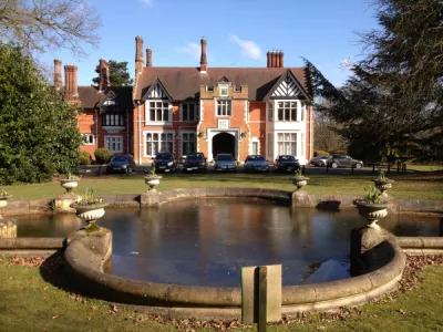
The turnpike, which ran roughly along the line of the modern A404 to connect the Great North Road at Hatfield to the Great West Road at Reading, was established in 1757, to regularise the previous arrangements whereby the parish was responsible for maintaining the roads within and passing through the parish. This obligation was laid by Acts of Parliament going back to Queen Mary 1 in the sixteenth century, and was becoming seen as very unfair to people who just happened to live on a ‘main road’ which provided them with no benefit but all the obligation: the user should pay and the money go to maintain the road. Tolls were collected at intervals, one of the toll booths being in this case near the present church and the pub ‘The Gate’, although whether that name owes anything to the road is unclear. But the road is unlikely to have affected Chorleywood much. Although it ran past the Cedars (built c.1862 on the site of the 17th century house previously lived in by Earl Russell of Chenies), Chorleywood House (built in 1822/3 on the site of two earlier farmhouses) and the Manor House (built in the 17th century or earlier as Meeting House Farm, extended and developed in the late 18th and early 19th centuries), the scattering of small settlements and isolated farms will have remained largely unchanged – the Drury and Andrews map of 1766 shows an improbable number of houses on the north-east side of the road, but only one ‘large’ house, probably the Manor house, nearby.
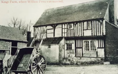
Chorleywood Bottom was mentioned in a manorial record of 1367, and Bullsland Farm, Clements Farm and Kings Farm date back to the early sixteenth century.[3] There were a number (twenty four have been identified[4]) of such small farms, all tenanted and part of various manorial estates including Micklefield Hall and Heronsgate. The hamlets included the Swillett, the Hammer, Soles (now Solesbridge Lane) as well as Chorleywood Bottom, but they were connected by pathways and tracks, with a walk even to Rickmansworth not easy. Many of these farms simply closed for various reasons, and have become part of the modern development of Chorleywood in the years around the First World War, partly as Metroland prompted by the Metropolitan Railway but also following the agricultural depression after 1870.[5] The story of these farms and the estates of which they were part is told well in the Chorleywood U3A book Exploring Chorleywood, available from libraries and Three Rivers Museum.
Non-Conformism was strong in this area, with Quakers and Baptists well established (William Penn and his wife Guilliema were married at Kings Farm in 1672), and Primitive Methodists having a chapel early in the 19th century; but the only Anglican churches were in Rickmansworth or Sarratt, which will have been more accessible for many albeit a different parish – bequests were made to Sarratt church by several Rickmansworth (quite possibly Chorleywood) parishioners as early as 1428.[6]
There was, however, no school in Chorleywood until 1853, when the new Anglican parish was established by the Bishop of London on the appeal of James Hayward of Loudwater, John Barnes of Chorleywood House and Prowting Roberts and with the new church paid for by these and other local gentry.[7] A house was provided for a schoolmaster with a school room attached, and just as the small church had to be replaced by the present building within twenty years the school expanded steadily – there may have been as many as 100 pupils by about 1870.[8]
The coming of the Metropolitan Railway resulted in the opening of Chorley Wood (sic) station, which very quickly resulted in a number of London commuters, who lived in houses provided generally nearby. This moved the centre of what was fast becoming a proper village to the south side of the line, although it was not until 1933 that steps and a bridge were provided to allow these passengers to get easily to the station. It also resulted in a considerable increase in the population, which climbed steadily from less than 1000 in 1881 (with most of them working either in agriculture or in one of the large estate houses) to about 13,000 in 2018.
Chorleywood was split from Rickmansworth civil parish in 1898, and became part of Watford Rural District until being again separated in 1913 as Chorleywood Urban District Council. It became part of Three Rivers District in 1974.
[1] Sue Clark, David Hiddleston, Hugh Howes, Gillian Pugh, Valerie Steel (‘Chorleywood U3A’), Exploring Chorleywood – a pictorial history (Chorleywood U3A, 2018); Gillian Pugh, The School on the Common – a history of Christchurch Chorleywood C of E school 1853 – 2020 (Rickmansworth, 2021), p.1
[2] Heather Falvey (ed), Pre-Reformation Wills from Rickmansworth Parish (1409 to 1539), (Rickmansworth, 2021), p.xxxviii.
[3] Pugh, School on the Common, p.1
[4] Chorleywood U3A, Exploring Chorleywood, p.9.
[5] Chorleywood U3A, Exploring Chorleywood, p.8
[6] Falvey, Rickmansworth Wills, pp.5, 14, 46, 52, 63, 65. John Creke was to be buried at Sarratt (p.46),
[7] Pugh, School on the Common, p.2.
[8] Pugh, School on the Common, p.7.


